
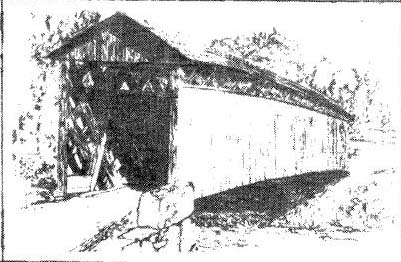
Hillsgrove Covered Bridge
Hillsgrove PA
Acrylic Painting December 15, 2015
Note: The bridge no longer exists.
Photo Contributed by Scott W. Tilden
Original auctioned on eBay in December 2015
Hillsgrove Covered Bridge
Hillsgrove PA
Acrylic Painting December 15, 2015
Note: The bridge no longer exists.
Photo Contributed by Scott W. Tilden
Original auctioned on eBay in December 2015
by Thomas Kipphorn
November 2007
Updated February 2011
Streams arranged alphabetically and the bridges from
source to mouth.
ELK
CREEK
PA/38-57-07x Elk Creek /
41° 31.02'N, 76°
39.74'W
HOAGLAND BRANCH OR A TRIBUTARY OF HOAGLAND
BRANCH
PA/38-57-14x High Bridge-
Unknown dimensions and truss type, but it likely was a single span. Some
of the maps are showing the site crossing Hoagland Branch, while others are
showing it as un unnamed tributary converging with Hoagland Branch further
south. Regardless, in Penn Pilot aerial photography dated to May 10, 1939,
the covered bridge is already gone. The bridge shown on Penn Pilot matches
the current bridge, which is scaling to about 55' on the Map 24 scale. It
was located in
41° 32.72'N, 76° 44.56'W
LEVEL BRANCH OF LICK
CREEK
PA/38-57-08x John Campbell's Mill /
41° 33.22'N, 76°
33.23'W

Photograph of the mill and covered bridge
taken just prior to 1899 before the great flood in December 1901 when the mill
was completely washed away.
The Covered bridge across Level Branch Creek showing
it's reflection in the mill pond.
The Covered
bridge was built in late 1849 connecting the wagon roads of Lick Creek and Kelly
Hill, by crossing the bridge to meet

One of the Covered
bridge's original main foundations that supported the north side of the bridge
coming down what is now called
All photos and captions courtesy Burke

Same view as above, courtesy of: http://freepages.genealogy.rootsweb.com/~dryer/page64.htm
LICK
CREEK
PA/38-57-09x
41° 30.54'N, 76° 35.10'W
Note: Big Loyalsock and Loyalsock
Creeks are the same stream.
LOYALSOCK
CREEK
PA/38-57-06x Worlds End Bridge-
Unknown
dimensions and truss type. In Penn Pilot aerial photography dated to April
16, 1939, the covered bridge is already gone and has been replaced by the same
bridge seen in current aerial imagery that is scaling to about 125' on the Map
24 scale. When comparing different aged maps, it appears the current
bridge is at the same site as the covered bridge. It was located in
41° 28.19'N, 76° 35.05'W
PA/38-57-01
41° 29.30'N, 76° 36.01'W
PA/38-57-02
41° 27.64'N, 76° 40.26'W
Note: Every photo I had seen until 2011
showed this bridge as a wrought iron through truss bridge. . So, I was doubtful of the existence of a
covered bridge here, since this stretch of the railroad only existed
about 18 years. However, I learned in 2011 that there were two bridges side by side *.
You can see the iron bridge in the
* Editor's Note: According to Melanie Norton of the Sullivan County Historical Society, in
March 2011, the wrought iron truss bridge mentioned is probably the one that was in front of the Little League
Camp Road that leads off Lincoln Falls Road going to High Knob Inn. She can remember when the state demolished
that one to put in an open span concrete bridge. Although it's still in Hillsgrove Twp., Sullivan County,
it had nothing to do with the Bridge(s) of Spooks on the south end of Hillsgrove
* Editor's Note: The second photo below, provided courtesy of Scott W. Tilden, shows the High Knob covered bridge itself
in an old RPPC postcard photo from about 1950. The unused postcard itself was auctioned on eBay in July 2012.
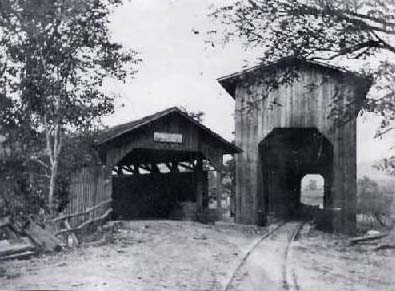
High Knob Covered Bridge and and Iron Truss Bridge
Side by SidePhoto courtesy of the
Sullivan County Historical Society and Museum
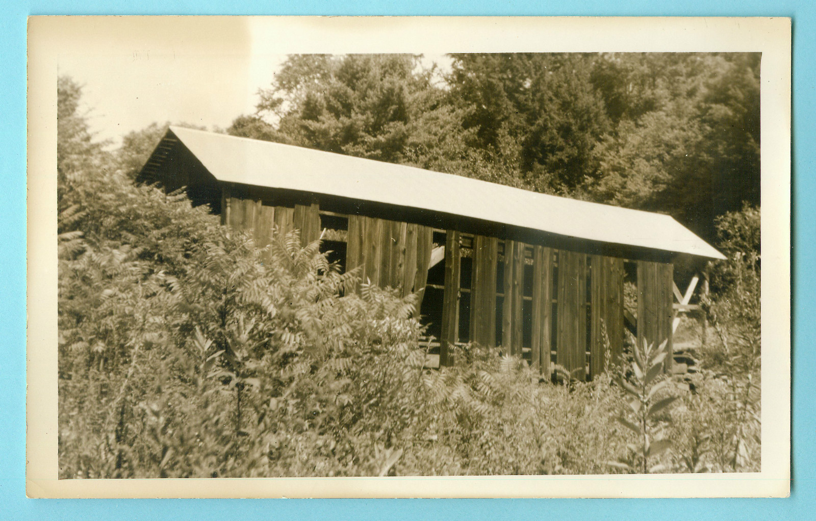
High Knob Covered Bridge
Photo courtesy of Scott W. Tilden
Original postcard photo auctioned on eBay in July 2012
PA/38-57-12x Susquehanna and Eagles Mere Narrow
Gauge Railroad Bridge at Hillsgrove-
"C.W. Sones was hired by the Union Tanning
Company to log a very large tract, 16 square miles, of lumber in 1902. He built
a 3' gauge railroad that connected to the Eagles Mere Railroad at
Original sources have it listed
with unknown dimensions and truss type, but it was built in 1904. If
there was a covered bridge at this site, it was very short lived, as
all photographs depicting the bridge at this site show it to be a wrought
iron through truss bridge, with the northern end resting on a pier, which is low
to the water and still in existence, followed by a short open span to the
shore. Current aerial imagery matches Penn Pilot aerial photography dated
to May 4, 1939, less the increased foliage. Dimensions from the pier to
southern streambank are measuring about 190'. It was found on the
Susquehanna and Eagles Mere Narrow Gauge Railroad, crossing at a northeast to
southwest angle with the southern abutment directly beside the southern abutment
of the
41° 26.35'N, 76° 42.70'W
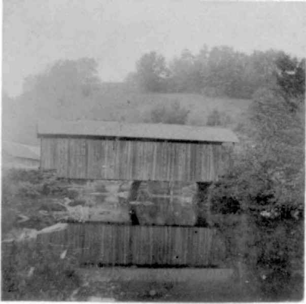
PA/38-57-05x Bridge of Spooks-
Two photos
of the bridge in Souvenir of Hillsgrove,
Valley of Dreams and Memories,a booklet published by Sullivan
Review Print, Dushore, PA in 1934, show it to be a single span Burr
Truss. Here was my source of confusion about the two bridges which actually stood next to each other;
The railroad bridge was
torn down in 1922, but the covered bridge lasted longer. There are at least 17 vertical posts,
which would put the
clear span in excess of 150'. It should be noted that the replacement
bridge, a Parker Through Truss, is standing at the same site and is 191' long,
with a 24' wide deck (Bridgehunter.com). The covered bridge was built in
1876 by John and Henry Hill and was condemned in August, 1934, then removed in
1935. Page 39 of the same booklet states: "The old wooden bridge was built
in 1876 by John and Henry Hill. It was the third bridge built on the
same foundation, the first falling in the creek, the second being torn
down. Parts of the second bridge were used towards building the
41° 26.36'N, 76° 42.73'W
LITTLE LOYALSOCK
CREEK
PA/38-57-10x Big Bottom Bridge-
Unknown dimensions and truss type, but as the stream
is only about 60' wide in the area, it likely was a single span. It was
located in
41° 30.41'N, 76° 32.63'W
PA/38-57-11x Forksville 2
Bridge- Unknown dimensions and truss
type, but the stream is scaling to about 85' on the Map 24 scale at the crossing
point. The covered bridge was removed in 1930. In Penn Pilot aerial
photography dated to May 1, 1939, the old road can clearly be seen on both sides
of the stream leading up to the site. It was located in
41° 29.51'N, 76° 36.01'W
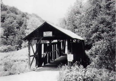
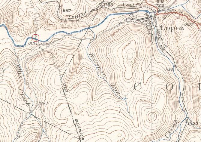
PA/38-57-16x Seemans Covered Bridge-
Existence of this bridge comes courtesy of Linda Burns. It was found in a 1947 genealogy book from the Penn
State University Library collection. Information on the location of the bridge is courtesy of Robert Sweeney,
the Sullivan County, PA historian. This bridge stood near the location of the Seemans Hotel (formerly Schreyvogel
Hotel) about two miles west of Lopez, PA. The current location is just north of the intersection of the Old
Berwick Turnpike coming up from the south and State Route 1004 (Seemans Road). The exact date of loss for
this bridge is unknown. The USGS Laporte Quadrangle, courtesy
of: http://historical.mytopo.com/statemap.cfm?stateabr=PA shows the site has been abandoned since at
least 1934. It was designed and erected by John Dieffenbacher (1813-1903). The bridge is near
the "new" (1947) Red Rock Turnpike. You can see from the photo below that it is also a
single span Town Truss style bridge. The biography of John Dieffenbacher, sixth son of
Jacob and Christina (Gardner) Dieffenbacher, an early settler of Sulliver County, states that John
designed and erected covered highway bridges and other types of bridges. Noteworthy ones
included the Tar Bridge over Lopez Creek on the Lee Settlement Road and the Seemans Covered
Bridge. Tar Bridge was the name of Lopez before it was incorporated in the 1880s. The
Tar Bridge was a wooden bridge that got its name because it was coated with coal tar to
protect the surfaces. It was not actually a covered bridge. The single span was supported
by two built-up wooden beams about 8' high, encased in hemlock boards. The floor system
was three by twelve stringers and a three-inch plank floor running with the road. It was a most unusual bridge design, but it carried the load.
The bridge appears to have been oriented north-northeast to south-southwest in Cherry Township about 300 ft north
of the intersection. Coordinates are close, but approximate.
41° 27.096'N, 76° 22.142'W
Seamans Covered Bridge
Located on the Schreyvogel/Seeman/Kachmarksy Property
West of Lopez, Sullivan County, PA
Photo courtesy of Linda Burns
Source: Thomas Pealer, Pealer-Wenner-Lawrence-Ladd-Dieffenbach
Families, 1947
Bridge site in relation to
Lopez.
Site appears abandoned in this USGS topographic map
taken from the 1934
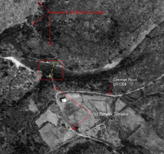
The bridge site, taken from a Penn Pilot aerial photograph, dated April 24, 1939.
Courtesy of: http://www.pennpilot.psu.edu/index.html
MUNCY
CREEK
Note: I can't tell if the center span below the train is wooden or
iron.
PA/38-57- Nordmont Railroad
Bridge- "The Muncy Creek Railroad, as the Williamsport and North
Branch was originally called, was chartered with Michael Meylert, H.R. Mehrling,
Robert Taylor, George Bodine and A.J. Dietrick as members of the
corporation. Their purpose was to lay out and construct a railroad from
Muncy,
The bridge was
built c.1888. It is not immediately known if the center span is wooden or
wrought iron. In Penn Pilot aerial photography dated to April 24, 1939,
there is nothing at the site. It was located between Davidson
and
41° 22.63'N, 76°
28.21'W

Location courtesy of Penn Pilot, as there
are several places it could have been.
PA/38-57-13x
41° 22.73'N, 76° 28.45'W

PA/38-57-03 Sonestown /
41° 20.77'N, 76° 33.31'W
Additional
sources:
Covered Spans
Campbellville
History of
Souvenir of