What follows is an attempt to trace the route of the turnpike, based on the Ingham History of Sullivan County, Pennsylvania, of 1899, and a 1872 map of Sullivan County.
In 1806 an act was passed [by the Pennsylvania Legislature] incorporating a company to be called
the Susquehana [sic] and Tioga Turnpike Road. The turnpike was designed to furnish a shorter route from Berwick to
the Tioga river at Newtown, now Elmira, NY.
Apart from the spelling of Susquehanna, there are two other items in the quotation that deserve
comment. The first is that sometime after 1806--probably in 1836 or later--the name of the river that now flows
through Elmira and past Newtown was changed from Tioga to Chemung, although the river upstream of the city of Corning
still retains the name Tioga,as does the point of land south of Athens, Pennsylvania, where that river flows
into the North Branch of the Susquehanna. The second item is that according to the web page of the city of
Elmira, three villages located at the present site of Elmira joined in 1792 to form the village of Newtown, and
then in 1828, the village of Newtown officially changed its name to Elmira. Other sources date the incorporation
as a village to 1815, and as a city to 1864. But the town of Newtown that existed in 1806 also included
the site of a battle in 1779 between about 4,000 Continental Regulars under General John Sullivan who defeated
but failed to capture the Delaware Indians that had tried to ambush them. The city of Elmira now stands today
at the site of the village of Newtown, but the town of Newtown included the site of Wellsburg, about seven
miles to the south, where Bentley Creek empties into the river..
Although initially chartered in 1806, the turnpike was not completed and opened until 1824--
according to the History of Chemung County, or in 1820, according to letters written at the time. The
road-builders objective was to construct a turnpike to connect Berwick and Newtown--a distance of roughly
85 miles. Over time, however, several alternative routes were apparently constructed for portions of the
turnpike. Returning to the 1899 history we find:
This company [formed in 1806] constructed a road in 1808 as far as the Loyalsock creek, and
in 1810 completed it to the Haverly settlement [in northwest Sullivan County]. From near the Long Pond
[now Ganoga Lake] it went directly to the Loyalsock, which it crossed about a mile below what is now Ringdale
Station, and crossed the Little Loyalsock near what is now Sicks Mill [currently, Cherry Mills, and continued
northward to the Haverly settlement.
The first twenty miles or so of the turnpike--from Berwick to Long Pond are fairly
straightforward. The road left Berwick (towards Newtown) following the current State Route (SR) 1025
north--8 miles--over Lee Mountain and Huntington Mountain, through Jamestown, then on SR 1023 and SR 4011--11 miles--
through New Columbus and Cambra, to Red Rock, where it followed SR 487--4 miles--to Ricketts State Park, and
departed from SR 487 for Long Pond. The route up Red Rock Mountain may not have followed the current SR 487,
because the difference in elevation between the base of the mountain at Red Rock and the top of the mountain is over one thousand feet.
Between Berwick and Newtown, the turnpike had to cross several mountain ranges, but
because Newtown is approximately north-northwest from Berwick, the road was usually built in that
direction except when it became necessary to follow the land's contours in order to achieve a gradual
decent to some stream, or an ascent from one. The description in the 1899 history makes it clear that, after
leaving Long Pond [Ganoga Lake], the initial turnpike went off on a more northwesterly direction towards
Ringdale (about ten miles from Long Pond). Indeed there is still a rather crooked trail to the Northwest
from a point about a mile beyond Ganoga Lake, a trail that passes through Thornedale, once a
thriving lumber town (but now deserted) and on to Ringdale, where the initial turnpike is supposed to
have crossed the Loyalsock Creek [referred to locally today as the Big Sock.
The route of the initial turnpike from the crossing of the Big Sock at Ringdale to the crossing
of the Little Sock at Cherry Mills is not entirely obvious; it may have followed one of the tributaries of
the Big Sock upstream to its origin, and then followed a stream leading down to the Little Sock on the other side
of the divide,or it may have gone more quickly up to a higher elevation--there are several roads that follow
a north-northwest direction. In any event, the locations where the turnpike crossed the two branches of the
Loyalsock creek become important distinctions between the initial route and the later routes
From Cherry Mills, the turnpike followed T 456, (in 1872, called the Old Pike) for 3 miles, and
at the end of T 456, it went left on SR 4016--1 mile--as it descended to Black Creek and crossed one of its
tributaries, and then followed Black Creek upstream, where it went right on T 452 and T 449 to Beebe Road--4 miles.
At the end of Beebe Road (in Overton Township, Bradford County), there are two possible routes from there
to Millstone Road. The left route (the more likely) follows Junks Pond Road--for 2 miles--to Millstone Road, and on
Millstone Road--for 6 miles--to Weston Road, and on Weston Road--for 2 miles--to Powell. The reason that this
route is more likely is that, by doing so, the turnpike would have followed the Genesee Road, built in 1800 from
Muncy, PA to the Tioga river. The Genesee Road passed through the western part of Sullivan County, PA, and
(according to the 1899 history) went down Millstone Run to Shraders Branch, which it followed down to Towanda Creek,
where it connected with other roads to the Tioga river. The alternate route for the turnpike (from the end of
Beebe Road) would have followed Deep Hallow Road--for 4 miles--to Millstone Road, and on Millstone Road--for
2 miles--to Weston Road, over which it would have gone the remaining 2 miles to Powell. Both routes ultimately
follow Millstone Creek to its junction with Towanda Creek, at Powell.
At Powell, the turnpike probably went west (down the Towanda Creek) about 3 miles on SR 414 to
Franklindale, where the route turned right to Banks Hill Road (the current SR 3013) for 4 miles, and then continued
on Franklindale Road to its junction with SR 3009 (Burlington Pike), which it followed for 2 miles to Burlington, PA.
At Burlington, the turnpike followed SR 4013 (today called Berwick Turnpike) for 17 miles through Bourne, Hoblet,
Middletown, and Centerville. The town of Hoblet is in Smithfield Township, and the Berwick turnpike is reported in
one place to have been constructed in 1819, and in another place to have been built through the township in 1820-21.
There is in Smithfield Township a Turnpike Cemetery. The turnpike passed through the northeast corner of
Springfield Township about a mile from Big Pond Road. From south of Middletown--in Ridgebury Township, north of
Smithfield and Springfield Townships--to the New York State line, the route followed Bentley Creek as it
flowed toward the Tioga River, and construction of that part of the turnpike is reported as having been done in
1820 or 1821. .
The turnpike entered New York State, where today the route becomes NY 367--to Wellsburg, 1 mile away.
Newtown battlefield is across the river from Wellsburg. From 1792 to 1808, the Wellsburg area was part of the
town of Newtown. Elmira is to the left (north) from Wellsburg--7 miles on NY route 427. If the initial turnpike was
completed end-to-end, it would probably follow the route described above as far as Wellsburg, where it
either went left along the west bank of the Tioga (now Chemung) River to the village of Newtown (now Elmira),
or its traffic used a road that already existed for those final 7 miles.
The 1899 Ingham history of Sullivan County relates that:
Supplements to the act of 1806 were passed in 1812 and 1815 [implying that somehow
the initial route was either unsatisfactory or uncompleted]. A new route was surveyed, and Andrew Shiner
took the job of building the road, and, in 1818, got it opened as far as Birch Creek [the boundary today between
the towns of Bernice and Mildred].
The first alternate route of the turnpike probably began near Long Pond (Ganoga Lake) at the
point where the initial route of the turnpike headed northwest towards Ringdale, and crossed the Big Sock.
This first alternate route of the turnpike headed north-northwest (about twenty degrees to the right of the initial
route at that point). The alternate route crossed the Big Sock west of Lopez, at the west end of SR 1004 (site of
the former Schreyvogel Hotel; the first lodging at this site, a shanty, having been built in 1818 to lodge the
workers on the turnpike. It was built by Amos Ellis, who later built a hotel. The first 10 miles (from Ganoga
Lake to Bernice) of this second turnpike route has no route number assigned today--but the turnpike route remains
the boundary between Davidson and Colley Townships of Sullivan County, as well as the boundary between Laporte and
Colley Townships. Between Ganoga Lake (once called Long Pond) and Bernice, this second turnpike route crossed
Spring Brook, Painter Den Creek, and Lopez Creek. [Although the bridges across these streams were no longer in
existence by 1946, the streams were shallow enough to be fordable.]
At Bernice, the alternate turnpike route rejoins SR 487, and crosses Birch Creek [the point
reached by the turnpike in 1818], and passes through the towns of Mildred and Shinersville. At the top of the
mountain--about 2 miles after leaving Bernice--the alternate turnpike made a left turn on SR 4024 to Cherry Mills
--4 miles--where it rejoined the initial turnpike route, and crossed the Little Loyalsock Creek
A second alternate route of the turnpike began a little north of Shinersville, where the first alternate route had turned towards Cherry Mills. Instead of heading towards Cherry Mills, the second alternate route followed SR 1010 to SR 1007--1 mile--into Dushore, where it crossed Little Loyalsock Creek. This route departed from Dushore on SR 4021 (once called North Turnpike Street). At the top of the hill, 1 mile after leaving Dushore, this route turned left to T 505 and T 432 to Coveytown, then to SR 4018, where it joined the earlier turnpike routes at the north end of Beebe Road.
A third alternate turnpike route would have started one mile north of Dushore, at the point where the second alternate route had turned left to join the earlier turnpike routes. This third alternate route would have continued on SR 4021 for two miles to its intersection with U.S. Route 220 (at the boundary between Sullivan and Bradford Counties). At that point the alternative turnpike route would have crossed (the current) U.S. 220 and descended to SR 2008, which (at Laddsburg)--after 2 miles--joins U.S. 220 North, along the valley of the South Branch (of the Towanda Creek) as far as Monroeton--11 miles. There are reports of the turnpike as having passed through both Albany Township and Monroe Townships in Bradford County. At Monroeton, the third alternate route would have followed SR 3009 (Burlington Pike) 9 miles to Burlington, where it would have rejoined the previous routes.
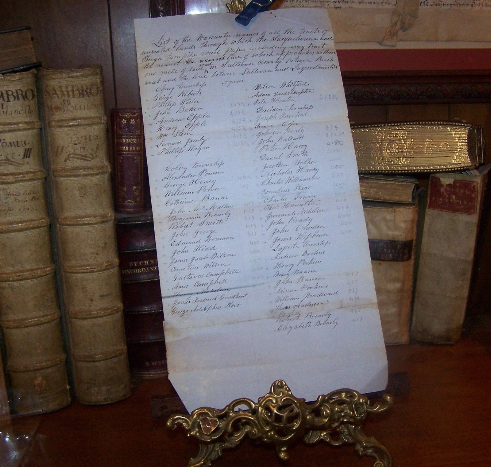
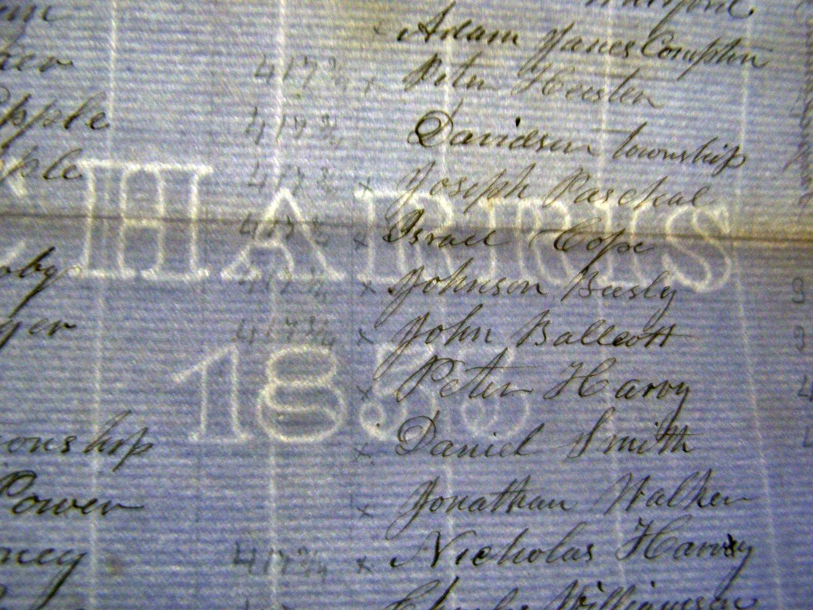
Editor's Note: In March 2015, eBay auctioned a handwritten list of landowners along the right-of-way of the Turnpike whose land holdings might affect, and vice versa, the
movement of goods and people along the route. The actual paper on which this document is written was manufactured in 1855 (based on its watermark) and, based on the history of
this type of mark, was likely used within six years of manufacture. So, we can date the document, shown below, to between 1855 and 1861.
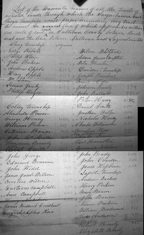
Landowners Affecting Susquehanna and Tioga Turnpike
Produced Between 1855-1861
Based on Watermark
Photo courtesy of Scott W. Tilden
Original Auctioned on eBay in March 2015
Click on Photo for Another View of the Document.
Here is a listing of the surnames written on this document (some of which are likely misspelled in the original):
Cherry Township: ROBERTS, STEIN, BAKER, EPPLER, STEIN, JACOBY, MAYER
Colley Township: POWER, HOVEY, POWER, BAUM, MULLEN, BREAVLY, SMITH, GEROGE, BOWMAN, KIDD, WILSON, WILSON, CAMPBELL, CAMPBELL, NICHELSON, GOODHEART, ADOPHHUS REV., WHITFORD, COMPTON, HUSTON
Davidson Township: PASCHAL, COPE, BEESLY, BALLCOTT, HARVY, SMITH, WALKER, HARVEY, WILLIAMSON, CONELIUS KERR, IRWIN, HAMILTON, NICKELSON, BRADY, COWDEN, HEPBURN
Laporte Township: BACHUS, PERKINS, BAUM, BAUM,PERKINS, WOODWARD, ANDERSEN, BRENCHLY, BRENCHLY
Full Description of Turnpike History from eBay Description of March 2015: The Susquehanna
and Tioga Turnpike, also called the Berwick and Tioga Turnpike, was a turnpike in northeastern .Pennsylvania. It extended 100 miles from from
Berwick, Pennsylvania to Elmira, New York, passing through Columbia, Luzerne, Sullivan, and Bradford Counties. The turnpike was established in 1807
and completed in 1825, and provided the shortest route between Elmira and Berwick. Traffic along it mostly ceased in 1907. Tolls along the turnpike
ranged from $0.03 to $0.20. The turnpike was commonly used for lime, iron, salt, and plaster.
The first portion of the Susquehanna and Tioga Turnpike was actually authorized on March 19, 1804. Starting in March 20, 1806, it was legally
permitted to build turnpikes in Pennsylvania. Six people from Philadelphia and six from Lycoming County were appointed as commissioners for the
company. In 1807, the Company of the Susquehanna and Tioga Turnpike Road was formed for the purpose of building a turnpike from Berwick, Pennsylvania
to Elmira, New York. The state of Pennsylvania donated 400 acres to the turnpike. Construction of the turnpike started in Berwick in 1808. From
here it proceeded north, reaching Loyalsock Creek in 1808, and the Painter Den property in 1809. Work on the turnpike ceased during the War
of 1812 but recommenced in 1816. The turnpike reached Towanda in 1818, the rest of Bradford County in 1823, and its northern terminus in 1825.
Soon after the turnpike was started, Andrew Shiner (1757-1844) was contracted to improve the turnpike, and by 1810, the Susquehanna and Tioga
Turnpike was the first road in good condition for wagons in its part of Pennsylvania.
The Susquehanna and Tioga Turnpike was built by men who lived in shanties, moving along the road as it was built. Both the people who built
the turnpike and those who first settled along it between 1820 and 1825 were predominantly Germans from southern Pennsylvania. However between 1840
and 1845, the area near the turnpike began to be settled by people of Irish ancestry as well. Starting in 1827, the Berwick and Towanda Turnpike
Company ran stagecoaches along the Susquehanna and Tioga Turnpike. The stagecoaches changed every 12 miles except for the part of the
turnpike that went over Red Rock Mountain. The stagecoaches left Berwick twice a day
The turnpike was closed in 1845 and changed to a public road. Starting in 1847, the road was largely succeeded by Pennsylvania Route 487, which
runs near the turnpike in Ricketts Glen State Park, and U.S. Route 220. From 1852 to 1907, the turnpike was a county road. Except for rare traffic
from jeeps and 4-wheel drive vehicles, the turnpike has not been used since 1907. A portion of the road was referred to as "useless,
inconvenient and burdensome". The turnpike is eligible for listing on the National Register of Historic Places.
The Susquehanna and Tioga Turnpike started in Berwick and went north over Jonestown Mountain (Knob Mountain) to Jonestown on Huntington Creek.
From there it went through Fairmount Township and Huntington Township in Luzerne County. From there, the turnpike followed a meandering and difficult
route up Red Rock Mountain and passed near Ganoga Lake. It then went through Sullivan County to the community of Lopez near Loyalsock Creek. An
area of the road in Sullivan County was referred to as the "Devil's mile" due to its poor condition. Upon reaching the border of Bradford County,
the turnpike went over Huckleberry Mountain to Monroeton, Towanda, and on to Elmira. At Elmira, it connected with a plank road running from east
to west. The Susquehanna and Tioga Turnpike served as an extension to the Susquehanna and Lehigh Turnpike, whose terminus was at Nescopeck
Falls. The turnpike was part of a larger network of turnpikes that formed a path from Philadelphia to Seneca Lake, New York, and beyond to Lake
Ontario and Niagara.
The Susquehanna and Tioga Turnpike was always rough and muddy and contained potholes during the summer. In the winter the turnpike was icy
partially due to beavers flooding the area near the turnpike. Both conditions often caused vehicles on the turnpike to become stuck. A common
remedy to this was to create a corduroy road consisting of logs laid perpendicularly to the rails below them. The turnpike was also not wide
enough for two vehicles, thus rendering collisions common. Additionally, some parts of the turnpike were too steep for horses to travel up
Tolls along the Susquehanna and Tioga Turnpike were less expensive for vehicles with one horse than those with two horses. Other animals carried
along the turnpike were charged on a case-by-case basis depending on the type of animal. For instance, in 1807, the toll for 20 sheep was $0.04,
the toll for 20 hogs was $0.06, and the toll for 20 cows was $0.12. The toll for a person riding a horse or mule was $0.03. The toll for a
two-wheeled vehicle with a single horse was $0.06 and with two horses the toll was $0.08. The toll for a four-wheeled vehicle with two
horses was $0.12 and for four horses it was $0.20. Tollgates were built along the turnpike to hold its revenue until the company's stock
was retired. One of the tollgates was called Watson Place and was most likely located near Ganoga Lake. In 1807, the Susquehanna and Tioga
Turnpike made $1339.07. Initially $60,000 of stock in the form of 600 shares was created for the company. Stock in the company that owned
the turnpike was sold at $100 per share. 10% of this stock was payable at the time of the purchase and the rest came in installments.
The Susquehanna and Tioga Turnpike received a moderate amount of use, especially during the spring, when the Susquehanna River was commonly
used as a method of travel to New York
While the Commonwealth of Pennsylvania provided some financial aid in the construction of the Susquehanna and Tioga Turnpike,
stockholders in the turnpike's company also incurred great expense. The turnpike did not pay off its investors. Despite this, it did improve
the lives of the people near it. In 1822, the Committee on Roads, Bridges and Inland Navigation of the Senate stated that "[The Susquehanna
and Tioga Turnpike] will afford facilities for traveling and transportation unequaled, as to extent, in the United States". A primary use of
the Susquehanna and Tioga Turnpike was to move livestock from northern Pennsylvania to the more densely populated areas along the Susquehanna River.
It was also used to move lime and iron northwards and to move plaster and salt southwards. Early travelers on the turnpike also included
loggers. Historically mail was delivered every three days along the turnpike. The turnpike also gave some importance to the community of Jonestown.
It also provided employment for many people and brought settlers into Columbia and Sullivan Counties
Dogwood in Pennsylvania
Tuscarora Township, PA
May 13, 2006
The dogwood is the tree with white flowers on the left.
Photo courtesy of Carol Brotzman
Copyright © 2002 Robert
E. Sweeney and individual Contributors. All Rights Reserved. Prior written
permission is required from Robert E. Sweeney and individual Contributors before
this material can be printed or otherwise copied, displayed or distributed
in any form. This
is a FREE genealogy site sponsored through PAGenWeb and can be reached directly
at ~Sullivan County Genealogy Project (http://www.rootsweb.com/~pasulliv)
